

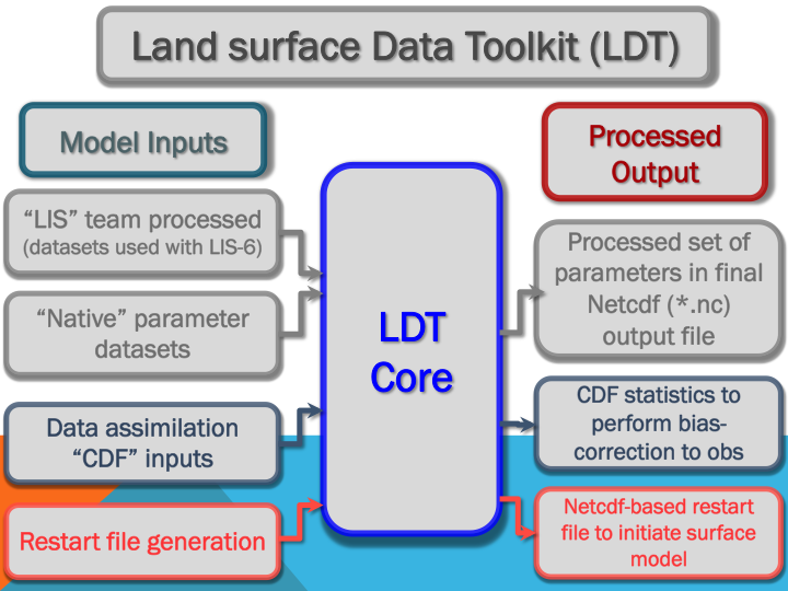
The Land surface Data Toolkit (LDT) is the front-end processor for the Land Information System (LIS), versions 7 and greater. It provides an environment for processing land model data and parameters, as well as restart files and data assimilation based inputs (e.g., for bias correction methods), and other data inputs for LIS and LVT (Arsenault et al., 2018).
LDT also offers a variety of inputs and user options to process datasets and is designed with not only LIS in mind, but for other independent model and modeling systems as well. LDT supports the use of common data formats, like NetCDF, which provide detailed data header information.
Some Major Features
- Processes data inputs for land surface, hydrological, and lake models.
- Writes output in NetCDF, a common descriptive format.
- Supports multiple observational data sources.
- Offers a variety of projections and grid transformation options.
- Includes numerous options for processing parameters (e.g., agreement between parameters).
- Can function as a stand-alone land surface and data assimilation input processor in addition to being a pre-processor for LIS.
New Data Options
Philosophy
LDT has been designed and developed to read in what are considered the "native" or raw original data files as how they are provided by a data center, government agency, university group, etc.
This philosophy that data and model parameter files should be read in from their "native" grids and file formats and be written to a common descriptive data format, like NetCDF, is supported throughout all of the LIS framework software. Finally, test cases are provided here to help demonstrate some of LDT's capabilities. Additional information can be found at the main FAQ Page.
Capabilities
LDT's Functional Goals involve developing certain key features, which include:
- Process surface model (e.g., land surface models) parameters onto a common grid domain.
- Generate model initial conditions (e.g., model ensemble initialization).
- Generate CDF statistics that can be used in LIS during data assimilation updates.
- Implement and apply quality control measures to parameters, independent validation datasets, etc.
- Process and temporally downscale meteorological forcing datasets.
- Support for processing observations for data assimilation procedures in LIS.
- Machine learning layer being developed and expanded for more applications.