

Contributions to the FEWS NET Seasonal Forecast Review Technical Discussion and background on the Forecasting in Africa and the Middle East (FAME) project.
NASA GSFC contributors: Amy McNally, Kristi Arsenault, Abheera Hazra, Christa Peters-Lidard
Climate Hazards Center, UC Santa Barbara Contributors: Shraddhanand Shukla, Alkhalil Adoum, Gideon Galu, Tamuka Magadzire, Laura Harrison
Edited by Juliet Way-Henthorne, Writer and Editor, Climate Hazards Center, University of California, Santa Barbara
For the past three months (August-October), the Forecasting for Africa and the Middle East (FAME) project has successfully contributed to Seasonal Agroclimatology Forecast Discussions for the Famine Early Warning Systems Network (FEWS NET), providing guidance on hydrologic conditions in East, West, and Southern Africa to support Food Security Outlooks (FSOs). Each month, the team kicks off a process that generates future estimates of soil moisture percentiles for these regions in Africa. Correspondingly, food security analysts at USAID/Chemonics develop “assumptions” about future meteorological conditions (e.g., 6 months into the future) for locations that they deem the most critical in addressing food security concerns. On approximately the 15th of each month, these assumptions and the forecasts are released, and FEWS NET team members at NASA Goddard Space Flight Center (GSFC) and UCSB Climate Hazards Center (CHC) combine this information and work with that of Africa-based regional scientists to provide feedback on the assumptions to the Food Security Analysts. The regional scientists also use this information in their other duties, including working with local meteorological agencies, FEWS NET regional technical managers, and the Crop Monitor for Early Warning.
For the October 2018 outlook, the forecasts were used to support flood risk assumptions in East Africa (Figure 1).

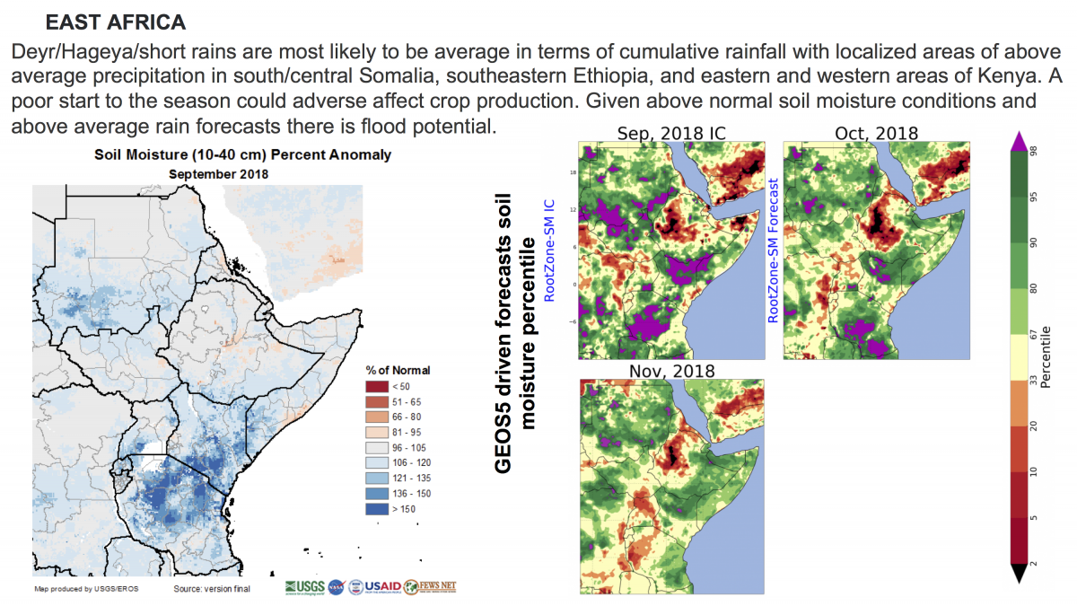
Figure 1. Current conditions are shown from NASA-based FLDAS soil moisture anomalies and forecasted percentiles showing ongoing wet conditions. This information supported the regional scientist’s assessment of the heightened level of flood risk for some regions in East Africa in the coming months.
The soil moisture forecasts were also used to support the potential for dry season moisture availability in West Africa (Figure 2).
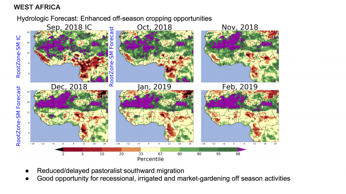
Figure 2. Soil moisture percentiles remain above average in the dry season, which the regional local scientist says is an indication that off-season “market gardens” may have above-average yields.
Forecasts are also used to support the current belief in southern Africa that, despite the fact that the El Niño onset may be normal, southern Madagascar’s prolonged drought (since 2014) is cause for concern.
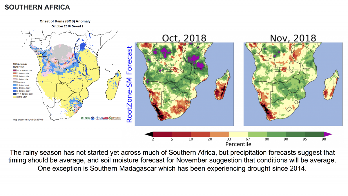
Figure 3. Soil moisture forecasts were presented along with current Start-of-Season progress supporting the regional scientist’s assertion that despite current El Nino development, conditions are generally expected to be average.
The FAME project was designed to help extend NASA’s FEWS NET Land Data Assimilation System (FLDAS; McNally et al., 2017) modeling and forecast capabilities by including additional land surface models (LSMs) and setting up a seasonal hydrologic forecasting system. Here is a schematic of the overall forecast system and its components:
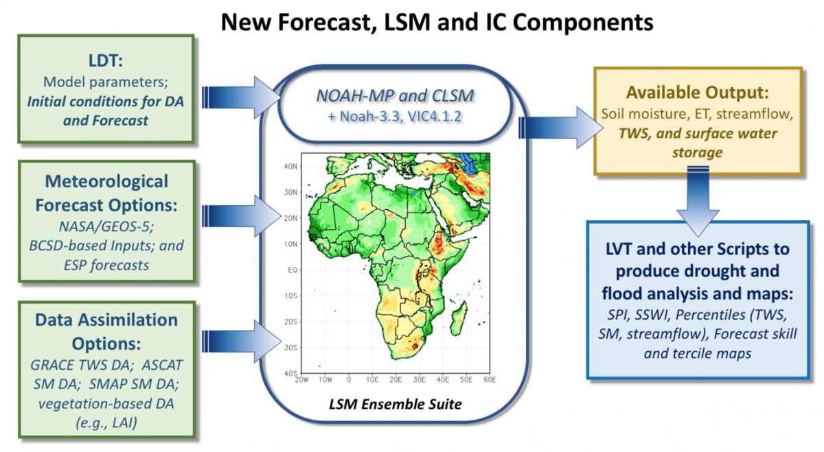
Figure 4. Diagram of overall FAME hydrological forecasting and modeling system components.
At this time, not many seasonal hydrologic forecasting systems exist that are in routine production, especially for Africa. Currently, the FAME hydrological forecast system utilizes three of NASA’s modeling and forecast capabilities, including the Land Information System (LIS) framework, the Catchment LSM (CLSM), and the Global Modeling and Assimilation Office’s GEOS-5 forecast model, which is one of the models in the North American Multi-Model Ensemble (NMME) suite. To bring the seasonal climate forecasts into a similar climatology of the historical model runs, which are used to generate the hydrological forecast initial conditions (ICs), we utilize a standard bias-correction and spatial downscaling (BCSD) approach (Wood et al., 2002). Bias correction allows us to blend the optimal inputs for FEWS NET and Africa (i.e., MERRA-2 and CHIRPS) with the selected forecast inputs (e.g., temperature and precipitation).
Currently, the monthly NMME model fields only include precipitation and temperature, while many other meteorological fields (e.g., shortwave radiation, winds) are required for running a hydrologic model. NASA’s GEOS-5 provides the entire suite of necessary meteorological fields and include daily timescales. FEWS NET often refers to other forecasts in their monthly telecon meeting, so we need to be aware of differences between NMME average and GEOS-5 when interpreting the results for FEWS NET applications (e.g., shown in Figure 5).
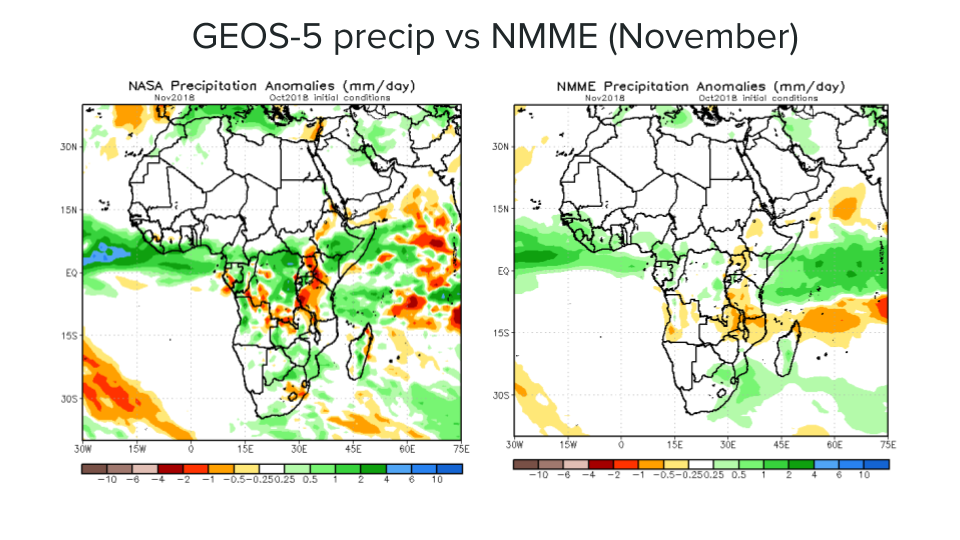
Figure 5. GEOS-5, version 2 (10-member), precipitation forecast compared to NMME model ensemble mean precipitation for November-2018 (lead month-1 of October forecast). The NMME model ensemble mean can have less of an anomalous signal, as shown with GEOS-5. Figures from CPC NOAA.
One issue faced while running the model and forecast initial conditions is that FEWS NET’s preferred rainfall data set, CHIRPS, lacks near-real-time availability (e.g., 20-day latency), which is also the case with MERRA-2 forcing. Thus, we generate our forecasts as soon as MERRA-2 data is available (e.g., the 11th of each month). To fill in the rainfall dataset gap, we use CHIRPS-prelim precipitation, which is known to have some differences, but generally has the same monthly mean.
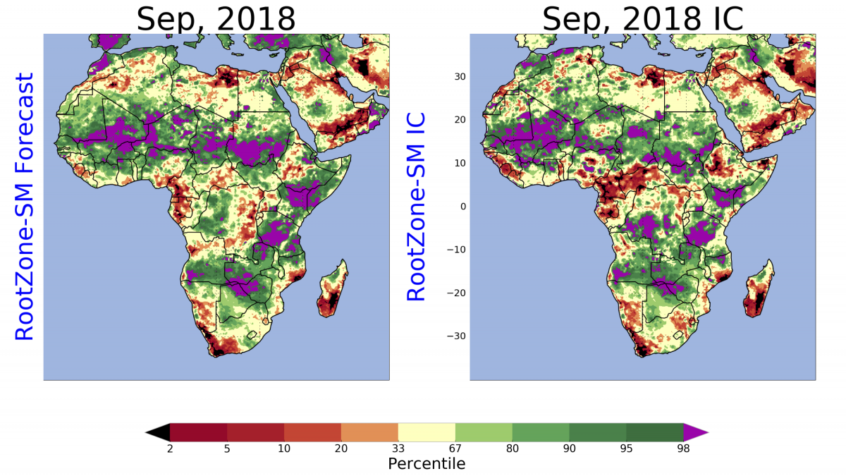
Figure 6. The September-2018 monthly forecast (lead-0) is shown in the left panel, which is initialized with the August CHIRPS-prelim initial conditions. The right panel shows the CHIRPS-prelim based September soil moisture ICs, which are used to generate the October-2018 forecasts. Note the differences in West Africa and Ethiopia. Additional work is planned in the future, including investigating any differences related to CHIRPS-final vs. CHIRPS-prelim ICs.
Finally, the 6-month soil moisture forecasts are produced for both the Noah-MP and CLSM land surface models, with 10-member ensembles each (given the GEOS-5 version 2). The results are converted into percentiles and are pooled using the median across the combined 20 model members. These final root-zone soil moisture percentiles are shown on the FAME webpage (https://lis.gsfc.nasa.gov/projects/fame) for the African continent and for the different regions.
Currently, we are producing routine monthly forecasts of soil moisture percentile at different levels (top-soil, root-zone, and total column), allowing us only the ability to weigh in on specific assumptions. For this reason, when the assumptions are released, we select those that are most relevant to antecedent precipitation and soil moisture conditions (e.g., flood or drought risk) and highlight these for the regional scientists. With this information, the plots on the webpage, and their incorporated expertise, they decide what information to present and discuss during the monthly telecons for the FEWS NET forecast science team on the call. If this information is particularly compelling, it is then passed back to the food security analysts to revise their assumption, repeating this process each month.
As research continues to develop related to the FAME objectives (e.g., data assimilation to help improve the forecast initial conditions and including additional hydrological variables, such as streamflow) new forecast outputs may get transitioned to routine operations depending on the addition of skill found with each new component. By phasing in new applications as they become more mature, the regional scientists will already be familiar with how to interpret results (e.g., soil moisture percentiles) and build trust with the products and product developers. This will allow them to provide better feedback regarding the improvement of the forecasts, e.g., with the data assimilation. We will continue with these applications, further automating the process to make it more routine and less “hands-on” and leaving more time to explore interesting and important research questions that will continue advancing improvements in hydrologic forecasting.
References
McNally, A., K. Arsenault, S.V. Kumar, S. Shukla, P. Peterson, S. Wang, C. Funk, C.D. Peters-Lidard, and J.P. Verdin, 2017: A land data assimilation system for sub-Saharan Africa food and water security applications. Scientific Data, 4, doi:10.1038/sdata.2017.12
Wood, A., E. Maurer, A. Kumar, and D. P. Lettenmaier, 2002: Long-range experimental hydrologic forecasting for the eastern United States. J. Geophys. Res., 107, 4429, doi:10.1029/ 2001JD000659.