

The Land surface Data Toolkit (LDT) provides an environment for processing LSM data and parameters, restart files and data assimilation based inputs (e.g., for bias correction methods) to the Land Information System (LIS).


Note: LIS Version 7 requires LDT processed inputs before its run-time execution...
LDT is the front-end processor to LIS-7. Image shows how it links to both LIS-7 and LVT.
LDT offers and will offer a variety of inputs and user options to processing datasets for use within LIS, version 7.0, (LIS-7). LDT is being designed with not only LIS-7 in mind but for other independent models and data processing systems as well. LDT supports the use of common data formats, like NetCDF, which provide detailed data header information for each data field.
The Philosophy of LDT
LDT has been designed and developed to read in what are considered the "native" or raw original data files as how they are provided by a data center, government agency, university group, etc. In the past, the LIS team has processed several different of the model and data parameters into a common binary format standard, which were provided to the community.
With the advent of LDT, we are introducing a "new" philosophy with this toolkit that data and model parameter files should be read in from their "native" grids and file formats and be written to a common descriptive data format, known as NetCDF. Several LDT test cases are provided here to help demonstrate some of LDT's current capability in reading in these "native" parameters. Additional information can also be found at the official LDT FAQ page.
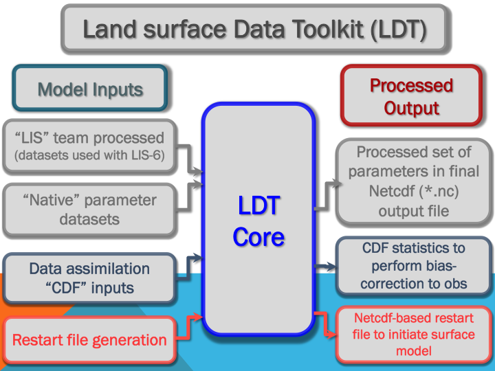
LDT's Current Capability
LDT Goals
LDT's Functional Goals involve developing certain key features, which include:
- Surface model (e.g., land surface models) parameter processing to a target model domain;
- Initial model condition generation (e.g., model ensemble initialization);
- Data assimilation inputs;
- Implement and apply quality control measures to parameters, independent validation datasets, etc.;
- Meteorological forcing bias correction (e.g., with independent observations) (coming soon);
- Model parameter optimization support (coming soon);
- Remote sensing product processing algorithm integration (coming soon).