

LIS is a flexible land surface modeling and data assimilation framework designed using advanced software engineering principles. Structured to enable community sharing and the reuse of modeling tools, data resources, and assimilation algorithms, the LIS infrastructure provides modeling tools to integrate satellite- and ground-based observational data products and advanced land surface modeling techniques to produce optimal fields of land surface states and fluxes.
The LIS Framework integrates these observations with model forecasts to generate improved estimates of land surface conditions such as soil moisture, evaporation, snow pack, and runoff (at 1km and finer spatial resolutions and at one-hour and finer temporal resolutions). The fine scale spatial modeling capability of LIS allows it to take advantage of Earth Observing System (EOS)-era observations, such as the Moderate Resolution Imaging Spectroradiometer (MODIS) leaf area index, snow cover, and surface temperature at full resolution.
LIS features a high performance and flexible design, provides infrastructure for data integration and assimilation, and operates on an ensemble of land surface models for extension over user-specified regional or global domains.
The system is designed as an object-oriented framework, with abstractions defined for customization and extension to different applications. These extensible interfaces allow the incorporation of new domains, land surface models (LSMs), land surface parameters, meteorological inputs, data assimilation, and optimization algorithms.
The extensible nature of these interfaces and the component style specification of the system allow rapid prototyping and development of new applications. These features enable LIS to serve as both:
- Problem Solving Environment (PSE) for hydrologic research to enable accurate global water and energy cycle predictions.
- Decision Support System (DSS) to generate useful information for application areas including disaster management, water resources management, agricultural management, numerical weather prediction, air quality, and military mobility assessment.
Features
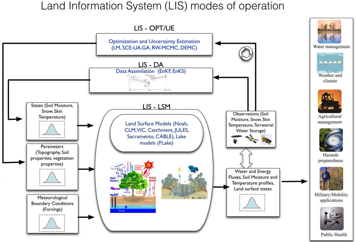
LIS currently includes a comprehensive suite of subsystems to support uncoupled and coupled land data assimilation.
A schematic of the LIS framework with the associated subsystems is shown in the figure above.
- The LIS-LSM subsystem, which is the core of LIS, supports high-performance, interoperable, and portable land surface modeling with a suite of community land surface models and input data.
- Further, the LIS-LSM subsystem is designed to encapsulate the land surface component of an Earth System model.
- The Data Assimilation (LIS-DA) subsystem supports multiple data assimilation algorithms that are focused on generating improved estimates of hydrologic model states; numerous observation datasets are supported.
- The Optimization-Uncertainty Estimation (LIS-OPT/UE) subsystem supports a suite of advanced optimization and uncertainty modeling tools.
- The LIS-WRF subsystem (not shown) supports coupled land-atmosphere modeling through both one-way and two-way coupling to the NASA-Unified Weather Research and Forecasting (NU-WRF) atmospheric model, leading to a hydrometeorological modeling capability that can be used to evaluate the impact of land surface processes on hydrologic prediction.